NAR is a competition where a team (pilot/navigator) must fly a specified route at a pre defined speed chosen by the team. (60-90kt) The route includes a 1NM corridor that participants must stay within to avoid penalties. The route has a clearly defined starting point (SP) and finishing point (FP) that competitors must pass at designated times. Turning points (TP) will be timed points. In addition there will be several secret time points (SC) along the route. Competitors are judged based on whether they can stay within the corridor and pass the time controls at the specified times. After the finishing point, each team must navigate through a "minefield" on their way back to the airport. Each "mine" hit will result in penalty points. The landing upon return from navigation will be scored and included in the total score. All scoring will take place live via the Air Sports Live Tracking system. Each team has their own sealed smartphone that functions as a logger and transmitter. In addition, each aircraft carries 2 traditional GPS loggers as a backup.
Live TV-show from the 2022 Norwegian championship: https://tv.nrk.no/serie/nm-veka/2022/MSPO51304822
Competition Days
Thursday 04.07
- Arrivals and practice.
Friday 05.07
- Qualification (long route)
- Airshows + Outdoor cinema: Top Gun Maverick (Open to public)
Saturday 06.07
– Landing Competition & Final (short route)
- Price giving ceremony and banquet
- Airshows + Concerts (Open to public)
Sunday 07.07
– Departures
Competition Fee & Registration (for visiting countries)
The competition fee will be €300 “all inclusive”:
- Accomodation - Thursday to Sunday (double rooms*)
Link to site - Breakfast, lunch & dinner – Friday & Saturday
- Breakfast – Sunday
- Free tickets to all shows Friday & Saturday
- Register here
- Registration Norwegian crews
*we will do our best to honor special request in regards to lodging, extra costs may apply.
Local Rules
Time Controls:
Known and unknown time controls are included along the route.
GPS Equipment:
GPS equipment, whether fixed or portable, showing track and/or ground speed is allowed. However, it can only be a receiver; devices with two-way communication are not permitted. GAC Precision Rules - A.2.2.18: The use of receivers that determine their position via analyzing satellite signals (GPS) is allowed. The use of any electronic device capable of two-way communication is not allowed (iPad, tablets, mobile phones, etc.). Equipment displaying maps below a scale of 1:500,000 or enabling route plotting for the competition is not allowed. Mobile equipment must not display any maps.
Minefield:
After the finish point, a minefield and danger areas are placed on the way back to landing. Forbidden areas (mines) incur a fixed point penalty each time they are entered, while danger areas incur a point penalty per second the participant remains in the specified area.
Map:
Each team receives a prepared map (1:250). The map includes the start, finish, corridor, known time controls, as well as forbidden zones and danger areas, compass course based on wind speed and direction, minute markers, and time control points according to the participant's specified speed.
Images:
The images should be of known time controls. The images should be taken in the direction of travel at a maximum angle of 45 degrees to the track. The images are presented in order of the route's direction of travel. The competition management will verify that the images are recognizable and have a clear circle around the object that is the time control.
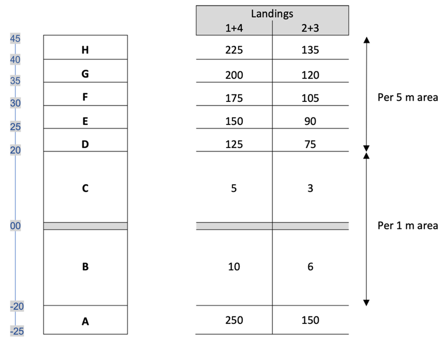
Landing - Local Rules Implementation:
When the team completes the navigation tasks, the subsequent landing is scored "live."
The landing will count as landing #1 in the landing competition. The landing competition itself will consist of three landings, #2 - #4.
The rules for the landings and landing competition will follow the Precision/ANR rules from the FAI/FAC landing appendix. https://www.fai.org/sites/default/files/documents/2023_gac_landing_appendix.pdf